


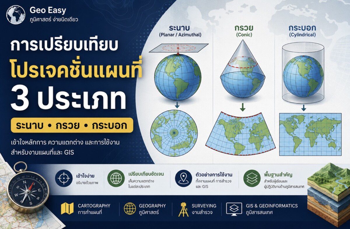
โปรเจคชั่นแผนที่ : ระนาบ กรวย และกระบอก
แผนที่เป็นเครื่องมือสำคัญในการศึกษาทางภูมิศาสตร์ การสำรวจ การวิเคราะห์เชิงพื้นที่ และระบบสารสนเทศภูมิศาสตร์ (Geographic Information System: GIS) อย่างไรก็ตาม เนื่องจากโลกมีลักษณะเป็นทรงกลมหรือทรงรี การถ่ายทอดพื้นผิวโลกลงบนแผนที่ซึ่งเป็นพื้นราบ จึงจำเป็นต้องใช้กระบวนการที่เรียกว่า “โปรเจคชั่นแผนที่” (Map Projection)
โปรเจคชั่นแผนที่ คือ กระบวนการทางคณิตศาสตร์ที่ใช้แปลงค่าพิกัดจากพื้นผิวโค้งของโลกให้อยู่ในรูปแบบสองมิติบนกระดาษหรือหน้าจอคอมพิวเตอร์ อย่างไรก็ตาม การแปลงดังกล่าวย่อมทำให้เกิด “ความบิดเบือน” (Distortion) ในด้านต่าง ๆ เช่น ขนาดพื้นที่ รูปร่าง ระยะทาง หรือทิศทาง ดังนั้น จึงไม่มีโปรเจคชั่นใดที่สามารถรักษาคุณสมบัติทุกด้านได้สมบูรณ์พร้อมกัน
โดยทั่วไป โปรเจคชั่นแผนที่สามารถแบ่งออกเป็น 3 ประเภทหลัก ได้แก่
- โปรเจคชั่นแบบระนาบ (Planar or Azimuthal Projection)
- โปรเจคชั่นแบบกรวย (Conic Projection)
- โปรเจคชั่นแบบกระบอก (Cylindrical Projection)
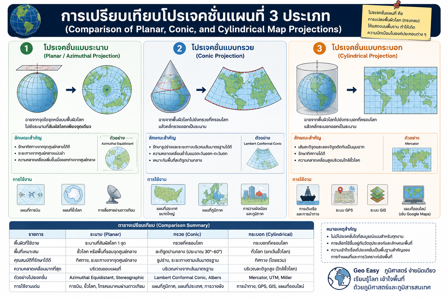
1. โปรเจคชั่นแบบระนาบ (Planar Projection)
โปรเจคชั่นแบบระนาบ หรือ Azimuthal Projection เป็นการฉายพื้นผิวโลกลงบนระนาบที่สัมผัสโลกเพียงจุดเดียว โดยส่วนใหญ่มักใช้บริเวณขั้วโลกหรือพื้นที่เฉพาะที่ต้องการความแม่นยำด้านทิศทางจากจุดศูนย์กลาง
ลักษณะสำคัญ
- รักษาทิศทางจากจุดศูนย์กลางได้ดี
- ระยะทางจากจุดศูนย์กลางมีความแม่นยำสูง
- ความคลาดเคลื่อนเพิ่มขึ้นเมื่ออยู่ห่างจากจุดสัมผัส
การใช้งาน
- แผนที่ขั้วโลก
- แผนที่การบิน
- ระบบสื่อสารผ่านดาวเทียม
ข้อดี
- แสดงทิศทางได้แม่นยำ
- เหมาะกับพื้นที่วงกลมหรือพื้นที่เฉพาะจุด
ข้อจำกัด
- พื้นที่บริเวณขอบแผนที่เกิดความบิดเบือนสูง
- ไม่เหมาะสำหรับการแสดงผลทั้งโลก
2. โปรเจคชั่นแบบกรวย (Conic Projection)
โปรเจคชั่นแบบกรวยเป็นการฉายพื้นผิวโลกลงบนกรวยที่ครอบโลก จากนั้นจึงคลี่กรวยออกเป็นระนาบ โปรเจคชั่นประเภทนี้เหมาะสำหรับพื้นที่ในละติจูดปานกลาง และประเทศที่มีการขยายตัวตามแนวตะวันออก–ตะวันตก
ลักษณะสำคัญ
- รักษารูปร่างและระยะทางบริเวณเส้นมาตรฐานได้ดี
- ความคลาดเคลื่อนต่ำในพื้นที่ละติจูดปานกลาง
- เหมาะกับการทำแผนที่ระดับภูมิภาค
การใช้งาน
- แผนที่ภูมิภาค
- แผนที่ประเทศขนาดใหญ่
- การวางผังเมืองและภูมิภาค
ข้อดี
- ลดความคลาดเคลื่อนในพื้นที่ระดับภูมิภาค
- เหมาะสำหรับประเทศในเขตอบอุ่น
ข้อจำกัด
- ไม่เหมาะกับบริเวณเส้นศูนย์สูตรหรือขั้วโลก
- ความบิดเบือนเพิ่มขึ้นเมื่อห่างจากเส้นมาตรฐาน
3. โปรเจคชั่นแบบกระบอก (Cylindrical Projection)
โปรเจคชั่นแบบกระบอกเป็นการฉายพื้นผิวโลกลงบนทรงกระบอกที่ครอบโลก ก่อนคลี่ออกเป็นแผนที่ระนาบ ถือเป็นประเภทที่ได้รับความนิยมมากที่สุดในการทำแผนที่สมัยใหม่
ตัวอย่างสำคัญ ได้แก่
- Mercator Projection
- Universal Transverse Mercator (UTM)
ลักษณะสำคัญ
- เส้นละติจูดและลองจิจูดตัดกันเป็นมุมฉาก
- รักษาทิศทางได้ดี
- พื้นที่ใกล้ขั้วโลกเกิดความบิดเบือนสูง
การใช้งาน
- ระบบ GPS
- ระบบสารสนเทศภูมิศาสตร์ (GIS)
- แผนที่ออนไลน์ เช่น Google Maps
- การเดินเรือและการนำทาง
ข้อดี
- เหมาะสำหรับการนำทางและงาน GIS
- ใช้งานร่วมกับระบบพิกัดได้สะดวก
ข้อจำกัด
- พื้นที่บริเวณละติจูดสูงมีขนาดเกินจริง
- ไม่เหมาะกับการเปรียบเทียบขนาดพื้นที่ทั่วโลก
สรุป
โปรเจคชั่นแผนที่ทั้ง 3 ประเภทมีหลักการและวัตถุประสงค์การใช้งานที่แตกต่างกัน ไม่มีโปรเจคชั่นใดที่สามารถรักษาคุณสมบัติของโลกได้ครบถ้วนทั้งหมด ดังนั้น นักภูมิศาสตร์ นักทำแผนที่ และผู้ปฏิบัติงานด้าน GIS จำเป็นต้องเลือกใช้โปรเจคชั่นให้เหมาะสมกับลักษณะพื้นที่และวัตถุประสงค์ของงาน การเข้าใจระบบโปรเจคชั่นจึงถือเป็นพื้นฐานสำคัญของการทำแผนที่ การวิเคราะห์ข้อมูลเชิงพื้นที่ และเทคโนโลยีภูมิสารสนเทศในยุคดิจิทัล
Geo Easy : ภูมิศาสตร์ ง่ายนิดเดียว
เรียนรู้โลก เข้าใจพื้นที่ ด้วยภูมิศาสตร์และภูมิสารสนเทศ
Comparison of the Three Major Types of Map Projections: Planar, Conic, and Cylindrical Projections
Maps are fundamental tools in geography, cartography, spatial analysis, and Geographic Information Systems (GIS). Since the Earth has a spherical or ellipsoidal shape, representing its curved surface on a flat map requires the use of a map projection — a mathematical transformation that converts the Earth’s three-dimensional surface into a two-dimensional representation.
Each map projection is designed to preserve certain spatial properties, such as shape, area, direction, or distance, while inevitably introducing distortion in others. Therefore, selecting an appropriate projection depends on the purpose of the map and the geographic extent of the study area.
Map projections are generally classified into three major categories:
- Planar (Azimuthal) Projection
- Conic Projection
- Cylindrical Projection
1. Planar Projection (Azimuthal Projection)
A Planar Projection projects the Earth’s surface onto a flat plane that touches the globe at a single point, typically at the poles or a specific central location.
Key Characteristics
- Preserves direction accurately from the central point
- Provides accurate distance measurements from the center
- Distortion increases outward from the point of contact
Applications
- Polar maps
- Aviation navigation maps
- Satellite communication systems
Advantages
- Accurate directional representation from the center
- Suitable for circular regions and polar areas
Limitations
- Significant distortion near map edges
- Not suitable for world maps
2. Conic Projection
A Conic Projection projects the Earth’s surface onto a cone placed over the globe. When the cone is unrolled into a flat surface, it produces a map particularly suitable for mid-latitude regions.
Key Characteristics
- Preserves shape and distance along standard parallels
- Low distortion in east–west directions
- Effective for countries or regions extending longitudinally
Applications
- Regional mapping
- National topographic maps
- Urban and regional planning
Advantages
- Well suited for mid-latitude regions
- Reduced distortion across broad regional extents
Limitations
- Less suitable for equatorial or polar regions
- Distortion increases away from standard parallels
3. Cylindrical Projection
A Cylindrical Projection projects the Earth’s surface onto a cylinder wrapped around the globe. After unrolling the cylinder, the resulting map displays meridians and parallels as straight lines intersecting at right angles.
Well-known examples include the Mercator Projection and the Universal Transverse Mercator (UTM) Projection.
Key Characteristics
- Meridians and parallels intersect at right angles
- Preserves direction effectively
- Severe distortion occurs near polar regions
Applications
- Marine navigation
- GPS systems
- Geographic Information Systems (GIS)
- Web mapping platforms such as Google Maps
Advantages
- Highly effective for navigation
- Compatible with GIS and coordinate systems
Limitations
- Polar regions appear greatly exaggerated
- Unsuitable for accurate global area comparison
Comparative Summary of the Three Projection Types
| Projection Type | Main Characteristics | Suitable Applications | Limitations |
| Planar (Azimuthal) | Accurate direction from center | Polar mapping, aviation | High edge distortion |
| Conic | Suitable for mid-latitudes | Regional and national maps | Less suitable near equator |
| Cylindrical | Effective for navigation and GIS | World maps, GPS, GIS | Severe polar distortion |
Conclusion
The three major types of ma
rojections — planar, conic, and cylindrical — are designed for different geographic and analytical purposes. No single projection can preserve all spatial properties simultaneously. Consequently, geographers, cartographers, surveyors, and GIS professionals must select projections according to the geographic characteristics of the study area and the intended application.
Understanding projection systems is therefore a fundamental aspect of cartography, spatial analysis, and geoinformatics in the digital era.
Geo Easy : Geography Made Simple
Understanding the world through geography and geoinformatics.






ความคิดเห็น