


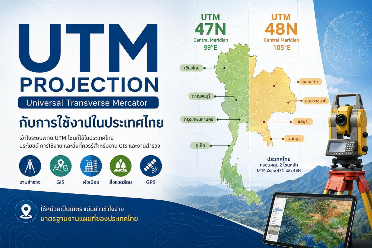
ระบบพิกัด UTM Projection (Universal Transverse Mercator) กับการใช้งานในประเทศไทย
ในการทำแผนที่ งานสำรวจ และระบบสารสนเทศภูมิศาสตร์ (GIS) หนึ่งในระบบโปรเจคชั่นที่นิยมใช้อย่างแพร่หลาย คือ “UTM Projection” หรือ Universal Transverse Mercator Projection ซึ่งเป็นระบบที่ออกแบบมาเพื่อให้สามารถคำนวณตำแหน่ง ระยะทาง และพื้นที่ได้อย่างแม่นยำในระดับภูมิภาคและระดับประเทศ
UTM Projection คืออะไร?
UTM Projection เป็นระบบโปรเจคชั่นแบบทรานส์เวิร์สเมอร์เคเตอร์ (Transverse Mercator Projection) ที่แบ่งโลกออกเป็นโซนตามแนวลองจิจูด โดยแต่ละโซนมีความกว้าง 6 องศาลองจิจูด
ระบบนี้ถูกพัฒนาขึ้นเพื่อแก้ปัญหาความคลาดเคลื่อนของแผนที่เมื่อแสดงผลบนพื้นราบ ทำให้สามารถใช้งานด้านสำรวจ วิศวกรรม และ GIS ได้อย่างมีประสิทธิภาพ
จุดเด่นสำคัญของระบบ UTM คือ
- คำนวณระยะทางและพื้นที่ได้แม่นยำ
- ใช้หน่วยเป็น “เมตร” ทำให้เข้าใจง่าย
- เหมาะสำหรับงานระดับประเทศ จังหวัด หรือพื้นที่เฉพาะ
- รองรับการใช้งานกับ GPS และระบบ GIS ทั่วโลก
หลักการของ UTM Projection
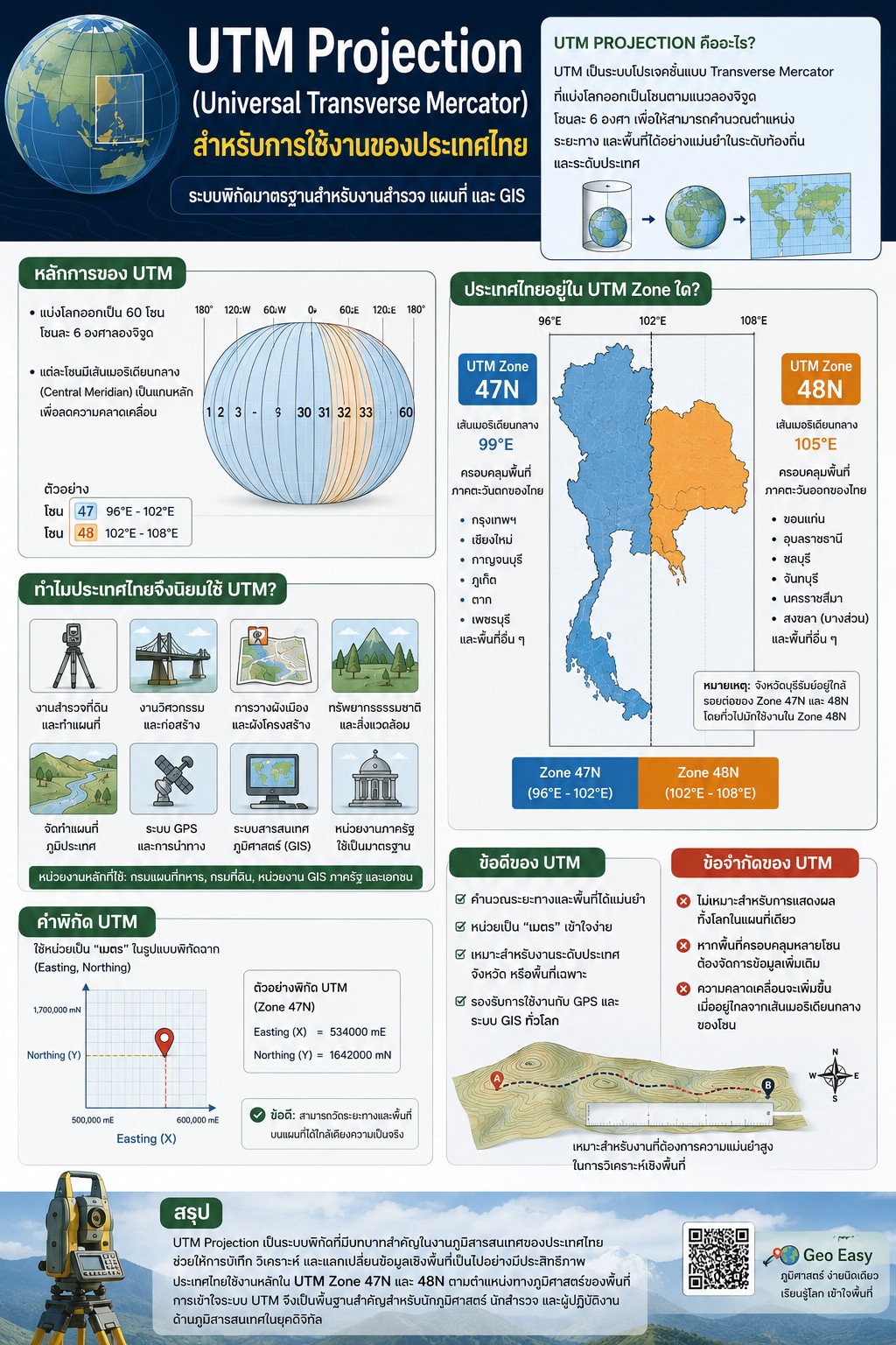
UTM ใช้วิธีแบ่งโลกออกเป็นทั้งหมด 60 โซน
แต่ละโซนกว้าง 6 องศาลองจิจูด
ตัวอย่างเช่น
- โซน 47 ครอบคลุมลองจิจูด 96°E – 102°E
- โซน 48 ครอบคลุมลองจิจูด 102°E – 108°E
แต่ละโซนจะมีเส้นเมอริเดียนกลาง (Central Meridian) เป็นแกนหลักในการคำนวณพิกัด เพื่อช่วยลดความคลาดเคลื่อนของข้อมูลเชิงพื้นที่
ประเทศไทยใช้ UTM Zone ใด?
ประเทศไทยตั้งอยู่ใน 2 โซนหลัก ได้แก่
1. UTM Zone 47N
ครอบคลุมพื้นที่ทางภาคตะวันตกของประเทศไทย เช่น
- กรุงเทพมหานคร
- เชียงใหม่
- กาญจนบุรี
- ภูเก็ต
โดยใช้เส้นเมอริเดียนกลางที่ 99°E
2. UTM Zone 48N
ครอบคลุมพื้นที่ทางภาคตะวันออกของประเทศไทย เช่น
- ขอนแก่น
- อุบลราชธานี
- ชลบุรี
- จันทบุรี
โดยใช้เส้นเมอริเดียนกลางที่ 105°E
จังหวัดบุรีรัมย์อยู่ใกล้รอยต่อของ Zone 47N และ 48N แต่โดยทั่วไปมักใช้งานใน UTM Zone 48N ในงาน GIS และงานสำรวจเชิงพื้นที่
เหตุใดประเทศไทยจึงนิยมใช้ UTM Projection?
ประเทศไทยนิยมใช้ระบบ UTM เนื่องจากเหมาะกับการวิเคราะห์เชิงพื้นที่ในระดับประเทศและระดับท้องถิ่น โดยเฉพาะงานที่ต้องการความแม่นยำด้านตำแหน่งและระยะทาง เช่น
- งานสำรวจที่ดิน
- งานวิศวกรรมโยธา
- การวางผังเมือง
- การจัดทำแผนที่ภูมิประเทศ
- งานด้านสิ่งแวดล้อมและทรัพยากรธรรมชาติ
- ระบบ GPS และการนำทาง
- ระบบสารสนเทศภูมิศาสตร์ (GIS)
นอกจากนี้ หน่วยงานภาครัฐของไทยหลายแห่ง เช่น กรมแผนที่ทหาร กรมที่ดิน และหน่วยงานด้าน GIS ต่างใช้ระบบ UTM เป็นมาตรฐานในการจัดเก็บและแลกเปลี่ยนข้อมูลเชิงพื้นที่
UTM กับค่าพิกัดที่พบในประเทศไทย
ค่าพิกัด UTM จะอยู่ในรูปแบบ
- Easting (X)
- Northing (Y)
โดยใช้หน่วยเป็น “เมตร”
ตัวอย่างเช่น
- Easting = 534000 mE
- Northing = 1642000 mN
ข้อดีของระบบนี้คือ ผู้ใช้งานสามารถวัดระยะทางบนแผนที่ได้ง่ายและตรงกับระยะจริงมากกว่าระบบพิกัดภูมิศาสตร์แบบละติจูด–ลองจิจูด
ข้อจำกัดของ UTM Projection
แม้ UTM จะมีความแม่นยำสูง แต่ก็มีข้อจำกัด เช่น
- ไม่เหมาะสำหรับการแสดงผลทั้งโลกในแผนที่เดียว
- หากพื้นที่ศึกษาครอบคลุมหลายโซน อาจต้องจัดการข้อมูลเพิ่มเติม
- ความคลาดเคลื่อนจะเพิ่มขึ้นเมื่ออยู่ไกลจากเส้นเมอริเดียนกลางของโซน
ดังนั้น การเลือกใช้ UTM Zone ให้เหมาะสมกับพื้นที่ศึกษา จึงเป็นสิ่งสำคัญในงาน GIS และงานแผนที่
สรุป
UTM Projection เป็นระบบโปรเจคชั่นที่มีบทบาทสำคัญในงานภูมิสารสนเทศของประเทศไทย เนื่องจากสามารถแสดงตำแหน่ง ระยะทาง และพื้นที่ได้อย่างแม่นยำ เหมาะสำหรับงานสำรวจ วิศวกรรม และระบบ GIS
ประเทศไทยใช้งานหลักใน UTM Zone 47N และ 48N โดยเลือกใช้ตามตำแหน่งทางภูมิศาสตร์ของพื้นที่ศึกษา การเข้าใจระบบ UTM จึงเป็นพื้นฐานสำคัญสำหรับนักภูมิศาสตร์ นักสำรวจ และผู้ปฏิบัติงานด้านภูมิสารสนเทศในยุคดิจิทัล
Geo Easy : ภูมิศาสตร์ ง่ายนิดเดียว
เรียนรู้โลก เข้าใจพื้นที่ ด้วยภูมิศาสตร์และภูมิสารสนเทศ
UTM Projection (Universal Transverse Mercator) and Its Applications in Thailand
In the fields of cartography, land surveying, and Geographic Information Systems (GIS), one of the most widely adopted coordinate reference systems is the Universal Transverse Mercator (UTM) Projection. This projection system was specifically developed to provide highly accurate spatial representation for position, distance, and area measurements at regional and national scales.
What is UTM Projection?
The Universal Transverse Mercator (UTM) Projection is a conformal map projection based on the Transverse Mercator system. It divides the Earth into longitudinal zones, each spanning 6 degrees of longitude. This approach minimizes distortion within each zone, making UTM particularly suitable for topographic mapping, engineering surveys, navigation, and GIS-based spatial analysis.
Unlike geographic coordinate systems that use latitude and longitude in angular units, UTM employs a projected coordinate system measured in meters, enabling more practical and precise distance and area calculations.
Key characteristics of the UTM system include:
- High positional accuracy for regional mapping
- Metric-based coordinates (meters)
- Compatibility with GPS and global GIS platforms
- Efficient spatial analysis for engineering and geospatial applications
- Reduced distortion within individual zones
Principles of the UTM Projection System
The UTM system divides the Earth into 60 longitudinal zones, each covering 6 degrees of longitude. Every zone is projected independently using a Transverse Mercator projection centered on its own Central Meridian, which minimizes scale distortion near the center of the zone.
For example:
- UTM Zone 47 covers longitudes 96°E – 102°E
- UTM Zone 48 covers longitudes 102°E – 108°E
Each zone is assigned a unique coordinate framework composed of:
- Easting (X-coordinate)
- Northing (Y-coordinate)
Both values are expressed in meters, making UTM coordinates intuitive for field measurements and spatial computations.
UTM Zones Used in Thailand
Thailand is geographically located within two primary UTM zones:
1. UTM Zone 47N
UTM Zone 47N covers western Thailand and uses the Central Meridian at 99°E. Provinces commonly associated with this zone include:
- Bangkok
- Chiang Mai
- Kanchanaburi
- Phuket
2. UTM Zone 48N
UTM Zone 48N covers eastern Thailand and is centered on the 105°E Central Meridian. Provinces within this zone include:
- Khon Kaen
- Ubon Ratchathani
- Chonburi
- Chanthaburi
Buriram Province lies near the boundary between Zones 47N and 48N; however, most GIS and surveying applications in the province commonly utilize UTM Zone 48N.
Why is UTM Widely Used in Thailand?
The UTM projection system is extensively used in Thailand because it provides reliable spatial accuracy for both national and local-scale applications. It is especially valuable in projects requiring precise coordinate positioning, distance measurement, and spatial analysis.
Major applications include:
- Cadastral and land parcel surveys
- Civil engineering and infrastructure development
- Urban and regional planning
- Topographic and thematic mapping
- Environmental and natural resource management
- GPS navigation systems
- Geographic Information Systems (GIS)
In addition, several Thai government agencies, including the Royal Thai Survey Department, the Department of Lands, and GIS-related institutions, employ UTM as a standard spatial reference framework for data management and geospatial data exchange.
UTM Coordinates in Thailand
UTM coordinates are represented using:
- Easting (X)
- Northing (Y)
Both are expressed in meters.
Example:
- Easting = 534000 mE
- Northing = 1642000 mN
One significant advantage of UTM is that distance measurements derived from maps correspond closely to real-world ground distances, unlike geographic coordinates expressed in degrees of latitude and longitude.
Limitations of the UTM Projection
Although UTM provides high spatial accuracy, it also has several limitations:
- It is not suitable for representing the entire world on a single map
- Spatial datasets spanning multiple zones require additional coordinate management
- Distortion gradually increases farther away from the Central Meridian of each zone
Therefore, selecting the appropriate UTM zone for a study area is essential in GIS analysis and cartographic production.
Conclusion
The Universal Transverse Mercator (UTM) Projection plays a fundamental role in Thailand’s geospatial infrastructure. Its ability to accurately represent position, distance, and area makes it indispensable for surveying, engineering, cartography, GPS applications, and GIS-based spatial analysis.
Thailand primarily utilizes UTM Zones 47N and 48N, depending on the geographic location of the study area. Consequently, understanding the principles and applications of the UTM projection system is essential for geographers, surveyors, GIS analysts, and geospatial professionals working in the digital geospatial era.
Geo Easy : Geography Made Simple
Understanding the world through geography and geoinformatics.







ความคิดเห็น