


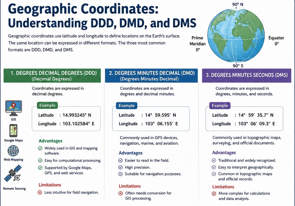
พิกัดภูมิศาสตร์ 3 รูปแบบ : DDD, DMD และ DMS
ปัจจุบัน GPS, Google Maps, GIS และระบบนำทางต่าง ๆ ใช้ พิกัดภูมิศาสตร์ (Geographic Coordinates) ในการระบุตำแหน่งบนพื้นผิวโลก
หลายคนอาจไม่ทราบว่า “ตำแหน่งเดียวกัน” สามารถแสดงได้หลายรูปแบบ โดยรูปแบบที่นิยมใช้ทั่วโลกมี 3 รูปแบบ ได้แก่
📍 Degrees Decimal Degrees (DDD)
📍 Degrees Minutes Decimal (DMD)
📍 Degrees Minutes Seconds (DMS)
แม้จะมีรูปแบบแตกต่างกัน แต่ทั้งหมดอ้างอิงตำแหน่งเดียวกันบนโลก
━━━━━━━━━━━━━━
🛰️ 1. Degrees Decimal Degrees (DDD)
แสดงพิกัดในรูปแบบ “องศาทศนิยมทั้งหมด”
ตัวอย่าง
14.993245° N
103.102584° E
การใช้งาน
✅ Google Maps
✅ ArcGIS
✅ QGIS
✅ Web GIS
✅ UAV Mapping
ข้อดี
✔ คำนวณง่าย
✔ เหมาะกับระบบคอมพิวเตอร์
✔ เป็นมาตรฐานหลักของ GIS
ข้อจำกัด
✖ ตัวเลขยาว จดจำยาก
✖ อ่านค่าภาคสนามได้ยากกว่ารูปแบบดั้งเดิม
━━━━━━━━━━━━━━
🧭 2. Degrees Minutes Decimal (DMD)
แสดงพิกัดในรูปแบบ “องศา + ลิปดาทศนิยม”
ตัวอย่าง
14° 59.595′ N
103° 06.155′ E
การใช้งาน
✅ เครื่อง GPS ภาคสนาม
✅ การเดินเรือ
✅ การบิน
✅ งานนำทาง
ข้อดี
✔ อ่านง่าย
✔ มีความละเอียดสูง
✔ เหมาะกับการนำทาง
ข้อจำกัด
✖ ต้องแปลงค่าก่อนใช้งานใน GIS บางระบบ
━━━━━━━━━━━━━━
🗺️ 3. Degrees Minutes Seconds (DMS)
แสดงพิกัดในรูปแบบ
องศา (°)
ลิปดา (′)
ฟิลิปดา (″)
ตัวอย่าง
14° 59′ 35.7″ N
103° 06′ 09.3″ E
การใช้งาน
✅ แผนที่ภูมิประเทศ
✅ งานรังวัด
✅ เอกสารราชการ
✅ งานวิชาการด้านภูมิศาสตร์
ข้อดี
✔ เป็นมาตรฐานทางวิชาการ
✔ เข้าใจตำแหน่งทางภูมิศาสตร์ได้ง่าย
✔ พบได้บ่อยในแผนที่ภูมิประเทศ
ข้อจำกัด
✖ คำนวณและประมวลผลยากกว่า DDD
━━━━━━━━━━━━━━
📌 พิกัดเดียวกันใน 3 รูปแบบ
🛰️ DDD
14.993245°, 103.102584°
🧭 DMD
14° 59.595′ N, 103° 06.155′ E
🗺️ DMS
14° 59′ 35.7″ N, 103° 06′ 09.3″ E
แม้รูปแบบตัวเลขจะแตกต่างกัน แต่ทั้งหมดคือ “ตำแหน่งเดียวกันบนโลก”
━━━━━━━━━━━━━━
🎯 จำง่ายสำหรับนักภูมิศาสตร์
🛰️ DDD = ภาษาของ GIS และ Google Maps
🧭 DMD = ภาษาของ GPS และการนำทาง
🗺️ DMS = ภาษาของแผนที่ภูมิประเทศและงานรังวัด
━━━━━━━━━━━━━━
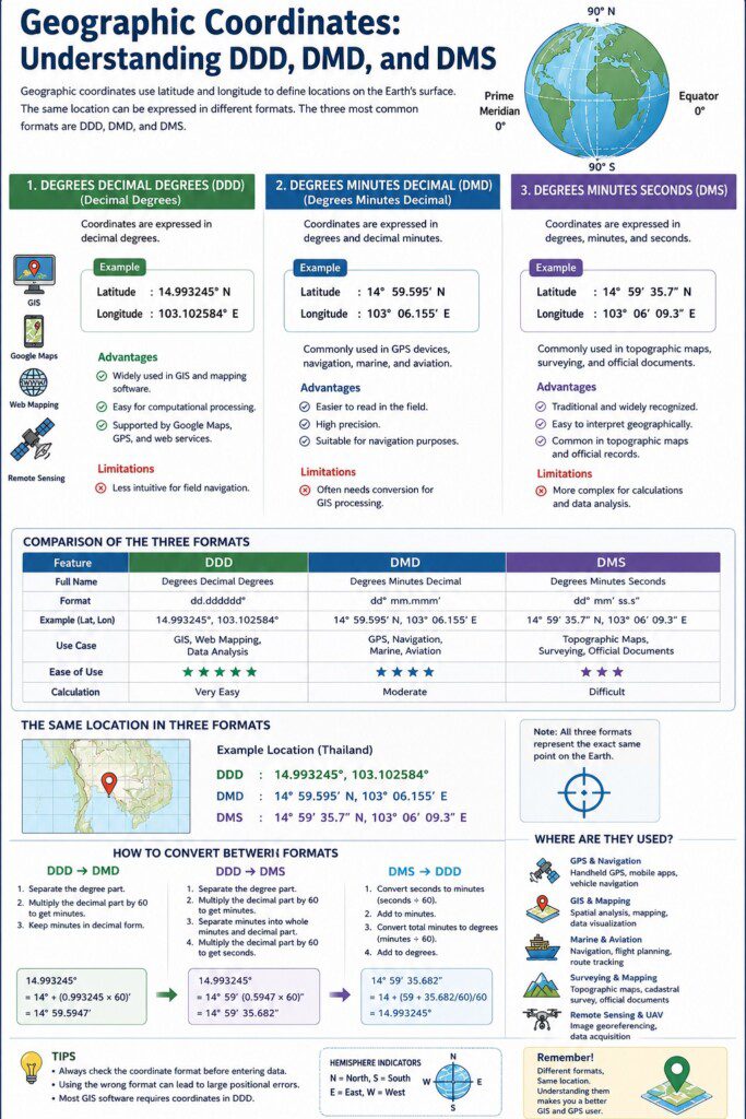
Geographic Coordinates: Understanding DDD, DMD and DMS
Geographic coordinates are the foundation of GPS, GIS, Google Maps, navigation systems, and modern geospatial technologies.
A single location on Earth can be represented in three commonly used coordinate formats:
📍 Degrees Decimal Degrees (DDD)
📍 Degrees Minutes Decimal (DMD)
📍 Degrees Minutes Seconds (DMS)
Although they appear different, all three formats refer to the same geographic position.
━━━━━━━━━━━━━━
🛰️ DDD (Degrees Decimal Degrees)
Example:
14.993245° N
103.102584° E
Commonly used in
• GIS Software
• Google Maps
• Web Mapping
• UAV Mapping
Advantages
✔ Easy for computer processing
✔ Ideal for GIS analysis
✔ Standard format in digital mapping
━━━━━━━━━━━━━━
🧭 DMD (Degrees Minutes Decimal)
Example:
14° 59.595′ N
103° 06.155′ E
Commonly used in
• GPS receivers
• Navigation
• Aviation
• Marine applications
Advantages
✔ Easy to read in the field
✔ High positional precision
✔ Suitable for navigation
━━━━━━━━━━━━━━
🗺️ DMS (Degrees Minutes Seconds)
Example:
14° 59′ 35.7″ N
103° 06′ 09.3″ E
Commonly used in
• Topographic maps
• Surveying
• Academic publications
• Government mapping agencies
Advantages
✔ Traditional and widely recognized
✔ Easy geographic interpretation
✔ Common in official mapping documents
━━━━━━━━━━━━━━
📌 Same Location, Three Formats
🛰️ DDD
14.993245°, 103.102584°
🧭 DMD
14° 59.595′ N, 103° 06.155′ E
🗺️ DMS
14° 59′ 35.7″ N, 103° 06′ 09.3″ E
All three coordinate formats represent exactly the same location on Earth.
━━━━━━━━━━━━━━
🌍 Geo Easy : Geography Made Simple
Understanding the World Through Geography and Geoinformatics







ความคิดเห็น